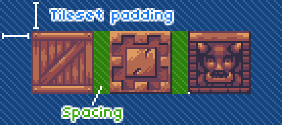
These coordinate IDs are a little bit more tricky than classic ones, because some tilesets can have padding and tile spacing.
For a given tileId (coordinate ID of a specific tile), you can get the atlas image pixel coordinates like this:
// Get "grid-based" coordinate of the tileId
var gridTileX = tileId - atlasGridBaseWidth * Std.int( tileId / atlasGridBaseWidth );

// Get the atlas pixel coordinate
var pixelTileX = padding + gridTileX * ( gridSize + spacing );
Same goes for the Y coordinates:
// Get "grid-based" coordinate of the tileId
var gridTileY = Std.int( tileId / atlasGridBaseWidth )

// Get the atlas pixel coordinate
var pixelTileY = padding + gridTileY * ( gridSize + spacing );